Mapping Detroit’s Digital Divide
Detroit & Metro Detroit, Michigan, USA
Young people in Detroit remain at a severe disadvantage if their households are unable to get online. This project combines publicly available spatial data with information gathered from interviews of high school students in the city in order to map detailed geographies of digital access and exclusion across Detroit’s neighborhoods.


-
Principal Investigators
-
Other Contributors
Salvador Lindquist
Reed Miller
Metrics
Funding Sources
- Taubman College of Architecture + Urban Planning, University of Michigan
About the Project
This mapping-based research and design project studies the digital divide in Detroit, focusing on Internet access in the city’s most disenfranchised neighborhoods.
As investors pour money into the residential and commercial development of areas like Downtown, Midtown, and Corktown, residents in marginalized neighborhoods lack access to digital infrastructure and the necessary skills to use information effectively once connected. Indeed, despite recent development, Detroit has the lowest rate of Internet connectivity in the United States, excluding thousands of people from the opportunities for education, employment, and belonging afforded to those with the ability to get online. This condition is exacerbated by the economic precarity of many Detroiters, the high costs of individual residentially-based internet access, and uneven broadband internet service provision throughout Detroit’s neighborhoods. Referred to as “digital redlining,” some view disinvestment in digital infrastructure for less affluent, non-white communities as commensurate to discrimination. Many of those affected are school-aged kids that need the Internet to complete their homework, submit job applications, or simply socialize with their classmates. While research shows that most teens have some access to the Internet via schools, libraries, or public WiFi connections, young people remain at a severe disadvantage if their households are unable to get online. As various grassroots and political organizations work to build a robust digital ecosystem, and urban development is increasingly influenced by broadband or wireless accessibility, what kinds of egalitarian spaces emerge under this evolving techno-infrastructure? If the Internet fosters a more complex sense of belonging, how is the built environment reconfiguring to support nascent social structures and promote inclusion? How does access (or lack thereof) to these virtual networks challenge conventional understandings of public and private space? How do teenagers in the iGeneration occupy or navigate a metropolis that is significantly offline? If citizens are emboldened by access to digital technologies, how might a community-driven network architecture breakdown certain hierarchies and power structures commonly found in the city?
To address these questions, this project combines publicly available spatial data in G.I.S. with information gathered from interviews of high school students in the city in order to map detailed geographies of digital access and exclusion across Detroit’s neighborhoods. The project identifies latent opportunities to reimagine Detroit’s disinvested neighborhoods in ways that enable public assembly and internet connectivity, proposing urban design scenarios that are rich with innovative ways to connect physically and virtually. Among other outcomes, the project results in detailed maps that articulate what would be necessary in order to develop strong community mesh networks across Detroit for internet access. By visualizing these invisible networks, this project hopes to create a heightened sense of community, empower citizens to create new spaces for public discourse in their neighborhoods, and redefine what digital access and equity could look like in the urban environment.
Download Online / On-site

Site Speculation #1, 4600 Martin

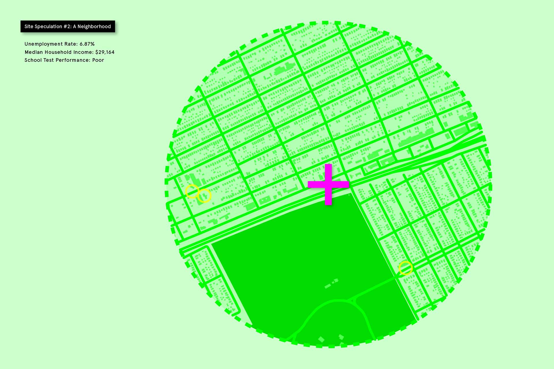
Site Speculation #2, 12800 Harper
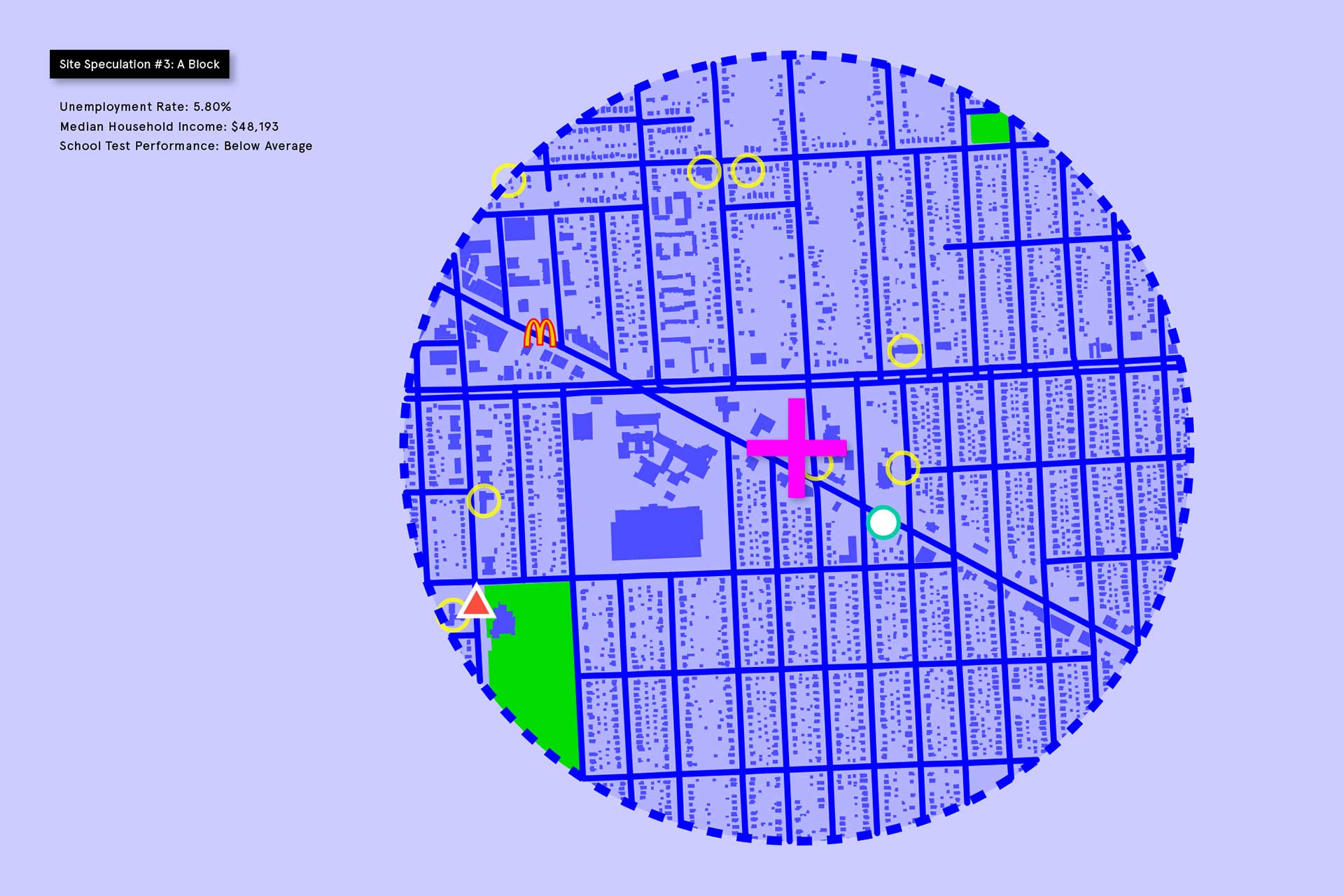
Site Speculation #3, 21200 Grand River
Related Projects


Using Technology to Keep Seniors Safe
Ypsilanti, Michigan, USA
Using wearable-based technology to help seniors stay mobile and age in place, while avoiding exposure to falls and environmental risks or hazards.
Learn More
Uber, Lyft, and New Transportation Options
Ann Arbor and Ann Arbor, Michigan, USA
Studying rideshare options like Lyft and Uber, with special focus on individuals with limited transportation choices.
Learn More
Improving Public Transportation
Benton Harbor, Michigan, USA
Collecting travel data to help Benton Harbor improve travel options for residents, with the goal of increased employment participation and retention.
Learn More
Increasing Mobility in Benton Harbor
Benton Harbor, Michigan, USA
Facilitating an on-demand, seamless, and efficient mobility service for the Benton Harbor community, especially among low-mobility families.
Learn More
Transforming Shipping Containers into Chronic Care Clinics
Sandy Bay, Hanover Parish, Jamaica
The first in a series of health clinic prototypes that bring technology-enabled chronic health care monitoring to remote, underserved global populations.
Learn More
Connecting Mobility and Social Access
Chicago, Illinois, USA
Rethinking how transit infrastructure can expand access to food, health, learning, and mobility services by creating multimodal hubs.
Learn More
Enhancing Decision Making along the Detroit Riverfront using Remote Sensing and Computer Vision Tools
Detroit & Metro Detroit, Michigan, USA
Using remote sensing and security camera data to better understand how people are using the Detroit RiverFront Conservancy public spaces.
Learn More
Remote Sensing Techniques for Highway Retaining Walls
Detroit & Metro Detroit, Michigan, USA
Structural monitoring of highway retaining walls using remote sensing techniques to assess performance and prioritize infrastructure investments.
Learn More

Demonstration Project for Real-Time Stormwater Control in Southeast Michigan
Detroit & Metro Detroit, Michigan, USA
Application of real-time sensing and dynamic control on existing wastewater infrastructure to reduce the frequency and volume of Combined Sewer Overflows.
Learn More
Point of Use Water Filters: A Grassroots Train-the-Trainer Program
Flint and Flint, Michigan, USA
A grassroots train-the-trainer program on how to install, operate and maintain faucet-mounted point-of-use filters to protect for lead in drinking water.
Learn More
Sensors in a Shoebox
Detroit & Metro Detroit, Michigan, USA
The Sensors in a Shoebox project focuses on empowering Detroit youth as agents of change for their city.
Learn More

Energy Savings through Integrated Personalized, Real-time Traveler Information and Incentive Scheme
Washington DC-Baltimore, Metropolitan Downtown Area, USA
The project aims to reduce energy use of vehicular travels by incentivizing individual travelers to adjust travel choices and driving behaviors.
Learn More
Bendable Concrete Utilized on a Bridge Deck (Engineered Cementitious Composite or ECC)
Ypsilanti, Michigan, USA
A major source of bridge deterioration requiring constant maintenance is mechanical expansion joints installed between adjacent simple span bridge decks.
Learn More
In-Place Structural Monitoring of Cast Iron Water Main Renewal
Detroit & Metro Detroit, Michigan, USA
The Great Lakes Water Authority is looking for ways to rehabilitate large diameter water mains without actually having to dig up city streets.
Learn More
Assessment of Risk for Southeast Michigan’s Drinking Water Transmission System
Detroit & Metro Detroit, Michigan, USA
The University of Michigan is developing a structural reliability framework to quantify the probability of failure of pipe segments throughout the GLWA system.
Learn More

Data-Driven Decision-Making Framework for Risk Management of the GLWA Water Transmission System
Detroit & Metro Detroit, Michigan, USA
The goal of this project is to develop a data-driven asset management framework that quantifies risk in the water distribution network for southeast Michigan.
Learn More
Ox Creek Corridor Visioning Project
Benton Harbor, Michigan, USA
The city of Benton Harbor wishes to transform Ox Creek into a residential, recreational and commercial centerpiece linking important segments of the community.
Learn More
Campus Martius & Cadillac Square – Enhancing the Benefits Of Community Parks
Detroit & Metro Detroit, Michigan, USA
While parks are designed and managed to generate community benefits, there remains a need for tools that can more rigorously measure how communities use parks.
Learn More
Partnering Workers with Interactive Robot Assistants to Usher Transformation in Future Construction Work
Ann Arbor and Detroit & Metro Detroit, Michigan, USA
Robots are anticipated to make the global construction industry safer and more attractive to workers, easing a worker shortage in the United States.
Learn More
State of Michigan Water Infrastructure Regional Planning
The State of Michigan, Michigan, USA
Recommendations were developed to promote regional planning to ensure infrastructure investments are equitable and result in high-quality drinking water.
Learn More
Great Lakes Legacy Act (GLLA) Restoration of the Rouge River
Detroit & Metro Detroit, Michigan, USA
The Urban Collaboratory is working with the USEPA and the Great Lakes Water Authority to remediate and restore the Rouge River.
Learn More
Enabling Independent Mobility in People with Physical Disabilities by Advancing Human-Centered Social and Technological Research
Ann Arbor and Ypsilanti, Michigan, USA
The goal of this project is to explore seamless and independent mobility for people with physical disabilities.
Learn More
Leveraging the City of Ann Arbor’s Water Treatment Pilot Plant to Inform Treatment of Emerging Contaminants Across the State of Michigan
Ann Arbor, Michigan, USA
The University of Michigan (UM) conducted a comprehensive research project in collaboration with the City of Ann Arbor Drinking Water Treatment Plant (AADWTP).
Learn MorePrincipal Investigators
Cyrus Peñarroyo
Principal Investigator
Assistant Professor of Architecture
Cyrus Peñarroyo is a Filipino-American designer and educator whose work explores the complex interrelations between architecture, contemporary media, and digital culture. He is an Assistant Professor at University of Michigan Taubman College of Architecture + Urban Planning, where he was the 2015‑16 William Muschenheim Fellow. Previously, he taught at Princeton University, Columbia University GSAPP, and School of the Art Institute of Chicago. Peñarroyo was awarded the 2019 Architectural League Prize and an ACSA Faculty Design Award Honorable Mention. His work has been exhibited at Materials & Applications in Los Angeles, Pinkcomma Gallery in Boston, The New School in New York, Princeton University School of Architecture, Harvard Graduate School of Design, and the 2014 Venice Biennale.
Peñarroyo received a B.S. in Architecture Summa Cum Laude from the University of Illinois at Chicago and an M.Arch from Princeton University. He worked for LTL Architects and Office for Metropolitan Architecture in New York, and Bureau Spectacular in Chicago. He was Project Lead on Manual of Section, published by Princeton Architectural Press and Cities Without Ground: A Hong Kong Guidebook, published by ORO. He is a partner of the design practice EXTENTS.